
 Niger
Niger
Detailed information on the analysis by crop is available for:
- Rice. Please check the sub-Saharan Africa rice page
- Sorghum. Please check the sub-Saharan Africa sorghum page
- Millet. Please check the sub-Saharan Africa millet page
Description of cropping systems, climate, and soils in Niger (by Dr. A. Alhassane)
In Niger, a landlocked country in West Africa, crop and livestock production are the foundation of the national economy, contributing about 40% to its GDP. Agricultural and pastoral activities are carried out in four distinct major agro-ecological zones namely: (i) the semi-desert area in the north, which receives 0 to 50 mm of rainfall per year, (ii) the sub-Saharan pastoral zone in the longitudinal East-West center core of the country and receiving 50 to 200 mm of rainfall per year, (iii) the Sahelian agro-pastoral zone extending in the central to southern part of the country and receiving 200 to 500 mm of rainfall per year, and (iv) the Sudano-Sahelian zone covering the southern part of the country, receiving 600 to 800 mm of rain per year, and being most suitable for agriculture.
In this vast country of 1,267,000 square kilometers, of which two-thirds is desert and the climate is hot and dry, agriculture is mainly rain-fed. Less than 10% of the cropped area is under irrigation and there are limited areas around permanent (i.e. the Niger and Komadougou-Yobe rivers) and semi-permanent (large ponds) water systems and in valley or dallol areas (dallols Bosso and Maoury) (Pini & Tarchiani, 2007). Most of Niger's agriculture is based on smallholder, subsistence farming systems and occupies over 12.5 Mha (with the area increasing annually by about 2%). Major cultivated crops are staples, with a clear predominance of pearl millet (46% of total acreage), sorghum (18%) and cowpea (32%). In addition to these main crops, there are other crops that are often grown under rainfed and/or irrigated conditions, such as cassava, sweet potato, rice, maize, wheat and fonio (finger millet). Cultivated area is expanding due to the development of irrigation schemes. Other crops such as cotton, groundnuts, Bambara groundnut and nutsedge are also cultivated in some regions, such as Maradi, Zinder and Dosso. It should be noted that the agricultural systems in Niger are mixed and that there is practically no region, where farms are exclusively specialized in one particular crop (Figure 1).
Intercropping (cereals-legumes or cereals-cereals) is widely practiced. In some areas with considerable soil heterogeneity across the field, a farmer may plant different crops (millet, sorghum, maize or legumes) in the same field. If the field has heterogeneous soil types, each crop is planted on the type of soil to which it is best adapted. One crop is usually cultivated per year (during the rainy season). Exceptions are areas around rivers and designated areas, where irrigation allows to cultivation of a second crop during the dry season (particularly, maize, rice, wheat, tubers and vegetable crops).
Agriculture in Niger is hampered by the strong intra- and inter-annual variability in rainfall (i.e. recurrent droughts). This variability largely explains the low and very fluctuating crop yields at both local and national levels (Table 1).
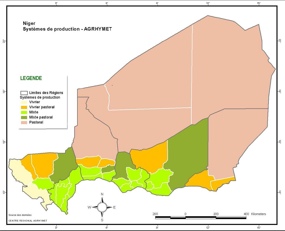
Figure 1 Production Systems in Niger (source : Centre régional AGRHYMET, Project AP3A)
Table 1 Averages (over 1999-2004 and 2010-2012) for productions, harvested areas and yields of the major food crops in Niger (source: Stratégie de Développement Accéléré et de Réduction de la Pauvreté (2008-2012); SRP, cabinet du Premier Ministre)
| Crop | Yield (T/ha) | Harvested Area (Million ha) | Total Production (Million metric tonnes) |
| Millet | 0.4492 | 6.0206 | 2.736 |
| Sorghum | 0.3047 | 2.5618 | 0.810 |
| Cowpea | 0.1857 | 4.1001 | 0.818 |
| Maize | 1.0049 | 0.0082 | 0.008 |
| Rice | 2.5489 | 0.0158 | 0.044 |
| Peanut | 0.4143 | 0.4640 | 0.192 |
Agriculture in Niger mainly utilizes traditional techniques and faces many challenges and constraints. The most important ones are the decrease in soil fertility, farmers without access or means to purchased inputs—including improved seed and fertilizers, lack of extension information, lack of access to quality seeds and agricultural inputs (especially fertilizers), poor management of irrigation water, frequent attacks by pests (locusts and other insects) and high population pressure. Together, these problems cause poor use of natural resources and worsen the recurrent food shortages that have occurred over the past four decades. Another aspect complicating implementation of agricultural development strategies in Niger is the heterogeneity and the complexity of its agricultural systems (Appendix A) which are associated with the variability in environmental factors (e.g., soil, microclimate and terrain (valleys, plains, sand dunes).
References
Cabinet du Premier Ministre (2007). Production, harvested area and yield of major food crops in Niger. Source: Stratégie de Développement Accéléré et de Réduction de la Pauvreté; SRP, 133P
FAO : www.fao.org/docrep/003/X6887F/x6887f0b.htm¿
Pini, G. et Tarchiani, V. 2007. Les systèmes de production Agro-Sylvo-pastoraux du Niger : 1.3 Description et Analyse. Working Paper n. 22 – 2007. ISSN 1774-4943 ISBN 978-88-96128-22-5. Centro Città del Terzo Mondo POLITECNICO DI TORINO Viale Mattioli 39, 10125 Torino – Italia www2.polito.it/ricerca/cctm cctm@polito.it. 77P
Appendix A Agro-ecological zoning of some agricultural systems un Niger (source: FAO - www.fao.org/docrep/003/X6887F/x6887f0b.htm¿)
| Caractéristique | Agricultural system 1 | Agricultural system 2 | Agricultural system 3 | Agricultural system 4 | Agricultural system 5 | Agricultural system 6 | Agricultural system 7 | Agricultural system 8 | Agricultural system 9 |
| Lake Chad Komadougou | Cuvettes Mainé Soroa | Eastern Plateaux | Goulbis | Ader-Doutchi Maggia-Tarka | Sand Dunes | Dallols | Plateaux | Rivers and tributaries | |
| Localization | Eastern Niger basin (N'Guigmi and Diffa departments) | South-West of Mainé and South-East of Gouré department | South and South-center (Diffa, Zinder, south east Maradi regions) | South-Center (Maradi region) | Maggia and Tarka valleys (Tahoua, Madaoua, Konni, Keita and Bouza departments) | Center (Tahoua, North Dosso and Tillabéry regions) | South east (Niamey, Boboye, Gaya and Doutchi departments) | South west (Dosso and Tillabéry regions) | West (Dosso, Tillabéry regions et Niamey district) |
| Approximative area | 0,37Mha | 0,01Mha | 2,5 à 7,5Mha | 0,2Mha | 0,2Mha | 18Mha | 0,5Mha | 2,5Mha | 0,91Mha |
| Climate and annual total rainfall | North Sahelian 250 - 300 mm/year | Dry Sahelian 300 - 350 mm/year | Sahelian 300 - 600 mm/year | Sahelian in the North and sahelo-sudanian in the South 300 - 600 mm/year | Sub-Sahelian 350 - 450 mm/year | Sahelian 300 - 450 mm/year | Sahelian in the Northa and sahelo-sudanian in the South 300 - 600 mm/year | Sahelianà l'ouest et soudano-Sahelianau sud | Sahelianau nord-ouest et sahélo-soudanien au sud |
| Topography and Hydrology | Bassin sédimentaire nappe affleurante | Dépression inter-dunaire Mare et nappe affleurements Modelé dunes vives | Vaste étendue de sable surmontée de plateaux et collines Mares temporaires et permanentes au Sud | Ancien lit d'écoulement, Nappe affleurante Mares permanentes et temporaires | Plateaux dégradés et vallées encaissées Mares et nappes affleurantes | Dunaire avec présence des plateaux latéritiques Nappes profondes | Fossil Valleys Nappes phréatiques affleurantes à faible profondeur | Plateaux latéritiques sur socle aplani entaillé de vallées | Vastes plaines entaillant les vallées du fleuve |
| Soils | Hydromorphe à pseudo gley | Sub aride brun rougeVertisols | Ferrugineux tropicaux | Sols lourds à gley et d'apport alluvial | Brun rouge des plateaux et à gley dans les vallées | Peu évolué et léger | Ferrugineux tropicaux hydromorphe, natronés par endroit | Ferrugineux sur plateaux, sableux au nord et limoneux au sud | Hydromorphe à pseudo-gley et vertisols |

Get access to the Atlas for advanced users
Download GYGA results
| Please read the license information in case you are interested in using the data from the Global Yield Gap Atlas. | |
| read more>> |
Country agronomists

Abdelkader Mahamane Soulé
Institut National de la Recherche Agronomique du Niger (INRAN)

Agali Alhassane