
 Extended Atlas for advanced users: Climate zone results at different scales
Aggregations to the climate zone level at national and global scale
To derive long-term yield indicators at climate zone level (Y climate zone), results at weather station level are aggregated to the climate zone level by calculating their area weighted average:
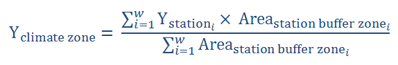
where Y station i is the long-term yield indicator at weather station level of station i, Area station buffer zone i
the harvested area in the buffer zone around weather station i and w the number of weather stations located within the climate zone.
A specific climate zone with the unique characteristics may be situated in different countries and in different continents. Consequently, climate zones can cross borders of neighbouring countries or may feature in different continents. This implies different options for aggregation:
- Consider climate zones per country: aggregate results from all weather stations that are located within a specific climate zone and within a country. This will result in climate zone results at a national scale.
- Aggregate all existing weather stations that are located within a specific climate zone, to obtain climate zone results at the global scale. So, each climate zone will have one value that reflects the global average of Yp, Yw, Ya and Yg.
In the extended Global Yield Gap Atlas for advanced users these two scales for cllimate zone results are all included. The default Global Yield Gap Atlas provides results for climate zones at national scale.
If you click on a climate zone, you will see its value and a table with all contributing weather stations and their values. For the climate zone results at national scale, the list consists of weather stations from one country. For the climate zone results at global scale, the table provides a worldwide overview of all contributing weather stations.
Note that a climate zone in a certain country only gets coloured if this climate zone holds a weather station that has been used to simulate yield potentials for the crop of interest.

Besides different climate zone aggregation levels the extended version for advanced users provides extra indicators for rainfed crops:
- Potential yield and related indicators:
- Potential yield (Yp)
- Yield gap based on potential yield (Yp - Ya)
- Relative yield ( Ya / Yp x 100% )
- Relative yield gap ( (1 - Ya / Yp) x 100% )
- the relative Water Productivity (Actual WP/Potential WP)