Uganda
Detailed information on the analysis by crop is available for:
- Maize. Please check the sub-Saharan Africa maize page
- Rice. Please check the sub-Saharan Africa rice page
- Sorghum. Please check the sub-Saharan Africa sorghum page
- Millet. Please check the sub-Saharan Africa millet page
Description of cropping systems, climate, and soils in Uganda (by Dr. K. Kaizzi)
Agriculture is one of the most important sectors of the Ugandan economy. It contributes about 20 percent of GDP, accounts for 48 percent of exports and provides a large proportion of the raw materials for industry[1]. The sector employs 73 percent of the population aged 10 years and older. About 4.0 million households in Uganda survive on small-holder farming and a significant proportion, (about 30%), of the population live below the poverty line and suffer food insecurity. About 25% of Ugandans are poor, corresponding to nearly 7.5 million in 1.2 million households[2]. Incidence of poverty remains higher in rural areas than in urban areas, with the poor in rural areas representing 27% of the population versus 9% in the urban areas. Therefore agriculture will be the key determinant in the country's efforts to reduce poverty in the immediate years ahead.
With a GDP per capita of USD 506 in 2008/09 and expected to reach USD 900 in 2014/15, Uganda is classified as a "Least Developed Country". It is confronted with the challenges of low productivity in the agricultural sector and major deficiencies in infrastructure and human development. In 2009 Uganda was ranked 157th out of 182 countries with data on the UNDP's Human Development Report with a Human Development Index of 0.514 which has been increasing steadily from 0.272 in 1995 to 0.581 in 2006 before reducing to 0.514 in 2009.
Agriculture has the potential to significantly increase its contribution to economic growth and poverty reduction. In 2008/09, agriculture grew by 2.6%. It has been estimated that if agriculture in Uganda grew at 2.8% per year, as experienced in the last eight years, the poverty rate would be reduced modestly to 27% by 2015. However if greater investments were made in agriculture and the sector grew at 5.9% per year to 2015, the national poverty rate would be reduced by an additional 9% points to 18% of the population and absolute number of poor people to 6.9 million. Therefore, investing more in agriculture to achieve higher economic growth rates is an effective vehicle for reducing poverty.
National Development Plan
The government of Uganda adopted a National Development Plan in 2010 with a vision: "A transformed Ugandan Society from a peasant to a modern and prosperous country within 30 years". This implies changing from a predominantly peasant low income to a middle income within 30 years.
Uganda drafted the Agricultural Sector Development and Investment Plan (DSIP) for the next five years and covers all sub-sectors of agriculture i.e. crops, livestock, fisheries and environment. This builds on the four priority programs identified by the National Development Plan. These include (i) enhancing agricultural production and productivity, (ii) improving access to and sustainability of agricultural markets, (iii) creating an enabling environment for investment in agriculture, (iv) institutional development for the agricultural sector. Closing current yield gaps contributes directly to priority (i).
Area under crop production
Of the estimated 5.13 Mha of land owned, only 4.42 Mha arable, and only about 58% of the total arable land was under crop production in 2008[3].
Major food crops
Cereals
Cereal crops grown in Uganda include; maize, finger millet, sorghum, rice, pearl millet and wheat in that order of importance. Other than wheat, these crops provide staple food for well over 50% of the population. They are also playing an increasing role in the provision of incomes of the rural households and the national economy. All these crops, other than wheat and rice, can be grown in most areas of the country. High potential areas for each crop are to a large extent, defined by rainfall amount and distribution. Maize requires medium to high rainfall that is well distributed throughout the growing season. As rainfall declines in duration and reliability, generally from south to north and westwards, finger millet becomes important. This in turn gives way to sorghum and finally pearl millet, as increasingly hardy crops that thrive in low rainfall environments. Wheat requires cooler temperatures and is grown in highland areas of the country such as Kapchorwa , located in the eastern and north western parts of the country, respectively.
Maize is grown in most parts of Uganda but most intensely in eastern (Kapchorwa, Mbale, Kamuli, Jinja, Iganga), central (Masaka, Mubende) and western (Masindi, Kamwenge, Kyenjojo, Kasese, Kabarole). Over 90% of Uganda's maize is produced by smallholders, of which about 60% of the annual maize output is consumed on the farm. The intensity of production appears to be a function of the position of the crop in the food system and the marketability of the crop. Maize can be grown twice a year (utilizing the bimodal rainfall opportunity) and continuously as long as it gives reasonable yield, and because of shortage of land to allow fallowing, this has caused a decline of soil fertility and grain yield. In many parts of the country, maize is intercropped with beans, soybeans or groundnuts.
Finger millet is the second most important cereal in Uganda after maize. Its production is concentrated in the east, north and southwest of the country. Up to 65% country's acreage is in the districts of Apac, Lira, Gulu, Kitgum, Iganga, Kamuli, Soroti and Tororo.
Grain sorghum is the third most important cereal crop in Uganda. It is widely grown in drier short grass areas in northern, eastern and south-western parts of the country. It is particularly important in the drought prone Karamoja region (Kotidi and Moroto districts), where it occupies 80% of the total crop acreage. It is also very important in Kabale, Kisoro and Rukungiri districts. It is more tolerant to drought than maize or finger millet, which makes it in important food security crop. It is a staple in much of eastern and northern Uganda. Sorghum plays important roles in the food security of the country and incomes of many rural households.
Rice is grown in many parts of the country but the principal areas are Gulu, Iganga, Tororo, Kitgum, Pallissa, Hoima, Kibale, Lira and Kumi. There is an increase in acreage under rice production because of the increased demand, and stability of farm-gate and retail prices. Government policy that encourages farmers to grow rice so as to ensure food security for this commodity, alleviate poverty and reduce the need to import rice. Among the crops grown in Uganda, rice is second to none in economic returns to the smallholder farmer on the basis of labor per man-day per ha[4].
Lowland rice is largely distributed in areas with extensive swamp networks. High potential areas for its production are found around Lake Kyoga. The acreage under lowland cultivation is increasing at 4000 ha/yr, most of which is reclaimed permanent wetlands[5].
Upland rice is a relatively new crop in Uganda's smallholder agriculture, but the consumption of rice is increasing due to its preference in school feeding and urbanization. Smallholder farmers consider rice primarily as a cash crop; production in 2006 was at 154000 tonnes; average yield was 733 kg/ha. Because the government has given increased rice production a high priority since 2000, the President launched upland rice growing in 2004, the UN's International Year of Rice.
Wheat is mainly produced in the districts of Kapchorwa, Kabale, Kisoro, Kabalore, Kasese, Bushenyi and Mbarara. Small quantities are also produced in Nebbi and West Nile districts.
Production statistics (2008/09)[6]
The regional and national production statistics of selected crops from the Uganda Census of Agriculture survey conducted during 2008/09 are presented in Table 1.
Table 1 Production Statistics of selected crops
|
| Acreage [ha] | ||||
| Crop | Central | Eastern | Northern | Western | Uganda |
| Maize | 189,135 | 388,762 | 247,780 | 188,583 | 1,014,260 |
| Finger millet | 5,832 | 86,911 | 105,656 | 5,588 | 249,987 |
| Sorghum | 2,261 | 101,645 | 249,330 | 46,016 | 399,252 |
| Rice | 2,637 | 36,033 | 25,912 | 10,504 | 75,085 |
| Beans | 120,798 | 108,107 | 146,702 | 241,915 | 617,521 |
| Banana (Food type) | 283,472 | 59,783 | 5,059 | 458,312 | 806,627 |
| Banana (Sweet type) | 8,596 | 3,039 | 3,932 | 7,556 | 23,129 |
| Banana (Beer type) | 34,014 | 6,682 | 204 | 45,228 | 86,127 |
| Cassava | 127,788 | 342,387 | 269,886 | 131,328 | 871,389 |
| Sweet potatoes | 98,054 | 159,948 | 60,573 | 121,681 | 440,256 |
|
|
|
|
|
|
|
|
| Production [Metric tons] | ||||
| Maize | 449,859 | 1,108,554 | 308,798 | 497,745 | 2,361,956 |
| Finger millet | 13,734 | 106,838 | 78,572 | 77,784 | 276,928 |
| Sorghum | 2,678 | 133,318 | 177,088 | 62,716 | 375,795 |
| Rice | 2,173 | 128,195 | 43,719 | 16,649 | 190,736 |
| Beans | 167,276 | 98,834 | 251,221 | 411,945 | 927,278 |
| Banana (Food type) | 929,534 | 333,851 | 26,015 | 2,728,587 | 4,017,986 |
| Banana (Sweet type) | 11,319 | 3,117 | 4,630 | 17,447 | 36,514 |
| Banana (Beer type) | 98,984 | 5,266 | 981 | 137,614 | 242,845 |
| Cassava | 409,812 | 1,061,186 | 983,124 | 440,189 | 2,894,311 |
| Sweet potatoes | 312,402 | 847,140 | 292,932 | 366,295 | 1,818,769 |
Farming systems
The country has eleven farming systems which are related to climatic differences, relief variation, and socioeconomic characteristics. The Farming systems in Uganda are presented in Figure 1. Annual cropping and cattle systems are mainly found in the northern part of Uganda and coffee and banana systems are mainly found in southern Uganda.
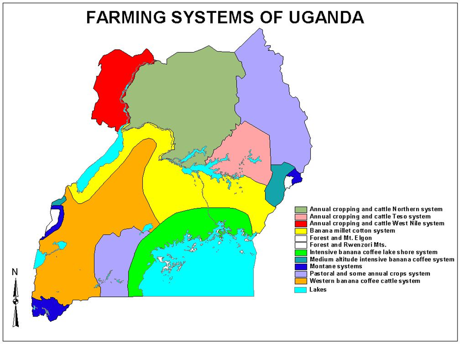

Figure 1. Farming systems of Uganda
Rainfall
The mean annual rainfall varies from 510 mm in parts of Karamoja to 2160 mm or more in Sesse Islands. More than 1520 mm fall on Mt. Elgon, Kabale, Bundibugyo, Gulu, and on the island and on north western shore of Lake Victoria[7]. More than 1100 mm fall along a 360-km arc around Lake Victoria from Tororo to Rakai and along a straight belt of similar length striking north-west from Tororo to Gulu. Rainfall is deficient in Karomoja, along a salient extending from Tanzania through Ankole to Lake Kyoga. The country is divided into 3 zones dictated by rainfall distribution. The unimodal which is found above 3° North latitude and the rest of the country south of this latitude experiences bimodal rainfall pattern with transitional zones between latitudes 1° and 3°.
Soils
The general distribution of Uganda's soil with the most and least productivity potential based on the Reconnaissance Soil Survey of Uganda[8] in which each soil unit is given an approximate potential productivity rating is presented in the following section
- Soils with productivity greater than average
- (i) Soils formed from parent material containing volcanic ash occurring on the lower slopes of Mt. Elgon in the eastern Uganda, on the triangle from Lake George and north of Lake Edward in western Uganda, around Fort Portal in Kabalore district, and
(ii) around Kisoro in south-west Uganda.
(b) Clays formed from parent material partly or wholly from basic amphibolite rocks which occur around Jinja and central Uganda and in small patches on the southern-most corner of Busia district, around Sunga in Kabale district; and in the south-west corner of Nebbi district.
(c) Deep, red or brown, loam or clay loam, pediment soils occurring in what was dubbed the "fertile crescent", 40 – 48 km wide around Lake Victoria from Jinja to south Masaka, in the rectangular block about 48 km wide, extending north-east from Fort Portal volcanic ash soils into north Mubende, as patches of dark-red clay loams, mainly lying between Hoima and Masind, in south-east Kabale district including Kabale, and around Ibanda Hill in Mbararar district
(d) Deep sedimentary soils occurring Around Bundibugyo in Bwamba County, Bundibugyo district, and in the neighborhood of Lira and around Dokolo in the south-east of Lira district.
- Soils with low or nil productivity
(a) Shallow or very sandy or gravelly soils which occur over most of the huge block country stretching from West Nile scarp across the whole of Gulu and Kitgum districts and much of Moroto and Kotido district, much of Katakwi, Kumi and Soroti districts, along the margins of Lake Kyoga and its branches and the north of central Uganda, along the margins of Lake Victoria in central Uganda, in the north and west of Masaka district up to Lake Wamala, and on the Singo hills north of Lake Wamala in central Uganda.
(b) Montane soils occurring on the upper slopes of Mt. Elgon and Rwenzori and patches of soils in western Uganda.
The coverage of the different soils of Uganda based on FAO classification is presented in Figure 2 below.
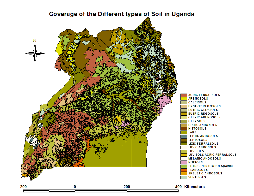

Figure 2. Coverage of the different types soils in Uganda
[1] UBOS (Uganda Bureau of Statistics). 2006. National Household Survey, Agricultural Module, Kampala, Uganda.
[2] UBOS (Uganda Bureau of Statistics). 2010. National Household Survey 2009/10. www.ubos.org/UNHS0910/unhs2009/10.pdf.
[3] Uganda Bureau of Statistics 2010 Summary Report on Uganda Census of Agriculture 2008/09
[4] Bank of Uganda, Agricultural Policy Secretariat, 1992
[5] National Environment Management Authority (NEMA), State of the Environment, 1994)
[6] Uganda Bureau of Statistics 2010 Summary Report on Uganda Census of Agriculture 2008/09
[7] Anonymous, 1962.
[8] Chenery, 1960

Get access to the Atlas for advanced users
Download GYGA results
| Please read the license information in case you are interested in using the data from the Global Yield Gap Atlas. | |
| read more>> |