
 Methods used in the Global Yield Gap Atlas
Methods used to estimate yield gaps in the Global Yield Gap Atlas (GYGA) were developed to improve:
(i) prioritization of public and private sector investments in agricultural research and development;
(ii) national forecasts of food production capacity, potential for food self-sufficiency, and variability of food production capacity due to variation in weather;
(iii) interpretation of historical yield trends and projections of future yield trends at regional, national and global scales.
Previous yield gap analyses are too coarse or too empirical to serve these purposes, and they lack transparency with respect to methods, sources of data, and underpinning assumptions, which makes it difficult to validate estimates or improve upon them (van Ittersum et al., 2013).
To address these deficiencies, the GYGA utilizes methods that are transparent, reproducible, and based on the best available science. Yield gaps (Yg) are estimated by the difference between yield potential (Yp) without limitations due to water or other abiotic and biotic stresses (the most relevant benchmark for irrigated systems), or water-limited yield potential (Yw) as the benchmark for rainfed systems, and actual crop yields (Ya). Water productivity (WP) is estimated as the ratio between Yw and crop water availability (potential WP) or between Ya and crop water availability (actual WP). Crop water availability is defined as the amount of water supply available during the crop growing season (from available soil water at sowing, precipitation, and also irrigation in irrigated systems) after discounting unavoidable water losses through surface runoff, deep drainage and the residual available soil water left in the soil profile at crop physiological maturity.
Eco-physiological crop simulation models are used to estimate Yp, Yw, and crop water availability to account for the influence of climate, soil-type and length of growing season as determined by climate, cultivar and dominant cropping systems at each location. In many parts of the world with sub-tropical and tropical climates, farmers grow two or three crops per year on the same field. In these regions farmers strive to optimize productivity of the entire cropping system rather than yield of a single crop to maximize returns to labor, land and time. Therefore, estimates of of Yp, Yw, and WP for a given crop in those systems must account for actual length of growing season as constrained by the cropping system.
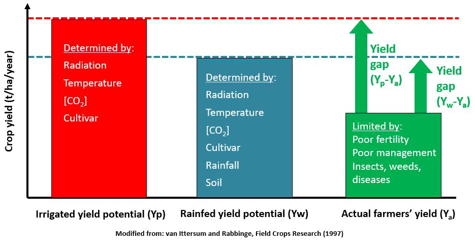
Fig. 1. Different production levels as determined by growth defining, limiting and reducing factors (Van Ittersum and Rabbinge, 1997; van Ittersum et al., 2013; Grassini et al., 2015; van Bussel et al., 2015). For irrigated systems and rainfed systems, respectively, potential yield (Yp) and water-limited yield (Yw) are the relevant benchmarks for yield gap analysis.
The "bottom-up" approach of the GYGA protocol allows use of actual location-specific data on current cropping systems, soil type, and long-term weather data from selected reference weather stations (RWS) so that results can be validated and improved upon as quality of such data improves and becomes available in major crop-producing regions worldwide. Where such data are of poor quality or not available, the GYGA utilizes the best existing data, or proxy data, with the goal of improving upon these data over time in a "wiki" concept. In all cases, sources of the underpinning data are specified and they are publicly accessible on the GYGA website (to the extent allowed by each source) for users who wish to perform their own yield gap assessment using other methods or to extend the analysis to include other crops and production scenarios. Use of robust crop simulation models to estimate Yp, Yw, and WP also allows assessment of yield stability and risk due to high or low temperatures and variability in rainfall at a given location.
Up-scaling location-specific estimates of Yp, Yw, Yg, and WP to regional and national levels is achieved by ensuring all major climate zones (CZs - as defined by Van Wart et al., 2013), soil types, and cropping systems are covered by the location-specific analyses at RWS, and by aggregating location-specific estimates to larger spatial scales by weighting for harvested crop area under each regime. These up-scaling methods are also transparent and reproducible, and they are applied consistently across crops and countries.
Details about each step in the GYGA protocol are provided under the following links:
6. Water productivity protocol
References
 Grassini P., Van Bussel L.G.J., Van Wart J., Wolf J., Claessens L., Yang H., Boogaard H., De Groot H., Van Ittersum M.K., Cassman K.G. How good is good enough? Data requirements for reliable crop yield simulations and yield-gap analysis. Field Crops Research. 177, 49-63
Van Bussel, L.G.J., P. Grassini, J. van Wart, J. Wolf, L. Claessens, H. Yang, H. Boogaard, H. de Groot, K. Saito, K.G. Cassman and M.K. van Ittersum. 2015. From field to atlas: Upscaling of location-specific yield gap estimates. Field Crops Research. 177, 98-108
Van Ittersum, M., Cassman K.G., Grassini, P., Wolf, J. Tittonell, P., Hochman, Z. 2013. Yield gap analysis with local to global relevance - A Review. Field Crops Research. 143, 4-17
Van Ittersum MK, Rabbinge R. 1997. Concepts in production ecology for analysis and quantification of agricultural input-output combinations. Field Crops Research. 52, 197-208
Van Wart J, van Bussel LGJ, Wolf J, Licker R, Grassini P, Nelson A, Boogaard H, Gerber J, Mueller ND, Claessens L, van Ittersum MK, KG Cassman. 2013a. Use of agro-climatic zones to upscale simulated crop yield potential. Field Crops Research. 143, 44-55

Maize production in Kenya